Current Data
Volcanoes
Find latest volcano alert levels on Alaska Volcano Observatory's map. 
Earthquakes
Was that a quake? Check Alaska Earthquake Center's recent earthquake list. 
Air Quality
Alaska Department of Environmental Conservation air quality advisory map. 
USGS Photo VolcanoesAlaska sits on the border between two huge tectonic plates. As the Pacific Plate slides beneath the North American Plate, mountains rise, the earth shakes, and volcanoes erupt. Two Alaskan volcanoes erupt every year on average.There are around 140 volcanoes in Alaska, with over 50 considered recently active (within the past 300 years). Most are located in the Aleutian Arc, part of the Pacific “ring of fire”. Visit Alaskan volcanoes at Katmai National Park & Preserve, Aniakchak National Monument & Preserve, and Alaska Maritime National Wildlife Refuge — but before you do, learn more about hazards here. 
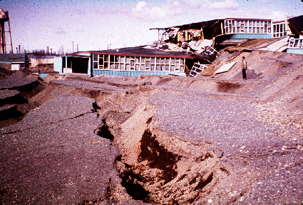
USGS Photo EarthquakesAlaska's magnitude 9.2 earthquake on March 27, 1964 remains the second-largest earthquake ever recorded. On average, the Alaska Earthquake Center records a quake every 15 minutes — almost 100 per day!Learn more about the 1964 earthquake from the U.S. Geological Survey, or visit the Anchorage Alaska Public Lands Information Center to watch the 25-minute film "The Day the Earth Shook". Sudden increases in earthquakes in the area surrounding a volcano can indicate that there may be an eruption soon. Find out more about the relationship between earthquakes and volcanoes at the Alaska Earthquake Center. 
USGS Photo Air QualitySeveral natural disasters can lead to air quality concerns, including volcano eruptions and wildfire. No matter the cause, there are some actions you can take to protect yourself, such as remaining indoors when possible, closing windows, and using a face mask.Alaskan communities can be significantly impacted by ashfall if they are downwind of an eruption, including Homer in 2009 with the eruption of Redoubt, and the Anchorage area after the 1992 Spurr eruption. Learn more about volcanic ashfall from the U.S. Geological Survey and the Alaska Volcano Observatory, and visit our Fire in Alaska page to learn more about wildfire smoke. Check current conditions using the links above. Prepare an emergency supply kit with this checklist from the Municipality of Anchorage.
Volcanoes
Find latest volcano alert levels on Alaska Volcano Observatory's map. 
Earthquakes
Was that a quake? Check Alaska Earthquake Center's recent earthquake list. 
Air Quality
Alaska Department of Environmental Conservation air quality advisory map. |
Last updated: March 24, 2025
