Last updated: October 5, 2022
Place
Los Alamos Wayside: A Volcanic Landscape
NPS
Quick Facts
Location:
Kwage Mesa Trail
MANAGED BY:
Amenities
1 listed
Historical/Interpretive Information/Exhibits
Main Text
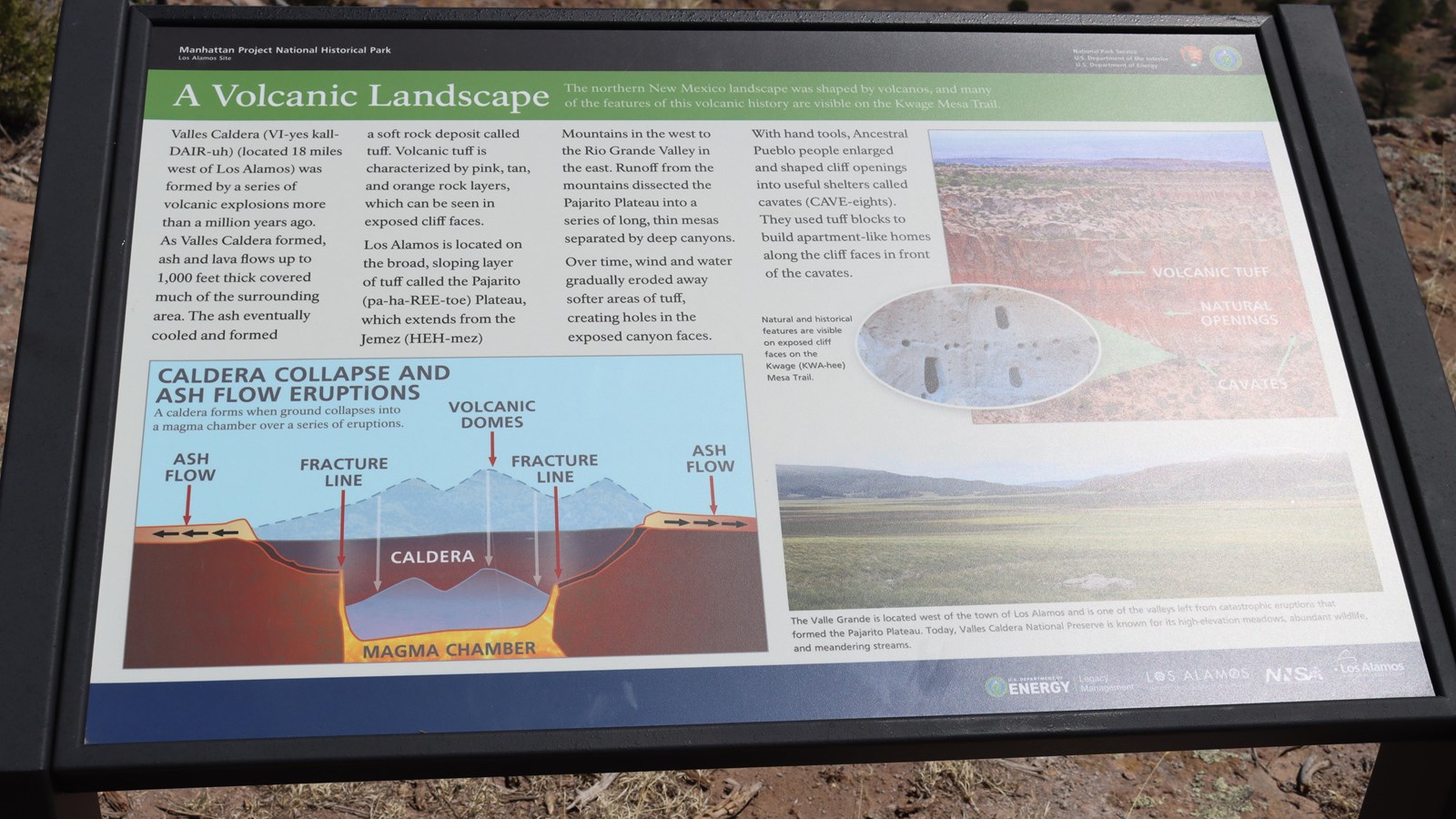
A Volcanic Landscape – The northern New Mexico landscape was shaped by volcanos, and many of the features of this volcanic history are visible on the Kwage Mesa Trail.
Valles Caldera (VI-yes kall-DAIR-ugh) (located 18 miles or 29 km west of Los Alamos) was formed by a series of volcanic explosions more than a million years ago. As Valles Caldera formed, ash and lava flows up to 1,000 feet thick covered much of the surrounding area. The ash eventually cooled and formed a soft rock deposit called tuff, is characterized by pink, tan, and orange rock layers, which can be seen in exposed cliff faces. Los Alamos is located on the broad, sloping layer of tuff called the Pajarito (pa-ha-REE-toe) Plateau which extends from the Jemez (HEH-mez). Mountains in the west to the Rio Grande Valley in the east. Runoff from the mountains dissected the Pajarito Plateau into a series of long, thin mesas separated by canyons. Overtime, win and water gradually eroded away softer areas of tuff, creating holes in the exposed canyon faces. With hand tools, Ancestral Pueblo people enlarged and shaped cliff openings into useful shelters called cavates (CAVE-eights). They used tuff blocks to build an apartment-like homes along the cliff faces in front of the cavates.
Exhibit Panel Description
A black band at the top of the wayside says, “Manhattan Project National Historical Park Los Alamos, New Mexico” On the right of the black band is the National Park Service log o and the U.S. Department of Energy logo. Below the black band a green band has the title of this wayside, “A Volcanic Landscape.” On the bottom left, a graphic shoes the “Caldera Collapse and Ash Flow Eruptions – A caldera forms when ground collapses into a magma chamber over a series of eruptions.” The graphic shows the caldera and magma chamber, the direction of ash flow, two fracture lines, and volcanic domes. On the top right, the side of the mesa pointing out the areas of volcanic tuff, natural openings, and cavates. A zoomed in image shoes the manmade holes in the rock. Text to the left of the image reads, “Natural and historical features are visible on exposed cliff faces on the Kwage (KWA-hee) Mesa Trail.” Below that image another image shows a wide, open, grassy meadow with mountains in the background. Below that image the text reads, “The Valle Grande is located west of the town of Los Alamos and is one of the valleys left from the catastrophic eruptions that formed the Pajarito Plateau. Today, Valles Caldera National Preserve is known for its high-elevation meadows, abundant wildlife, and meandering streams.” A blue bar at the bottom has “U.S. Department of Energy | Legacy Management, Los Alamos Where Discoveries Are Made, NNSA, and Los Alamos National Laboratory.”
Visit This Exhibit Panel
This wayside is located along the Kwage Mesa Trail. The Kwage Mesa stretches out on the north side of Los Alamos. To get to the trailhead from 15th Street and Central Avenue in downtown Los Alamos, head west (towards the Jemez Mountains) on Central. In 0.8 miles (1.28 km), past Ashley Pond, and the Aquatic Center, turn right onto Diamond Drive. Pass the Los Alamos High School and the Los Alamos Golf Course to the San Ildefonso roundabout located 2.4 miles (3.86 km) from the intersection of Central and Diamond. Bear right on San Ildefonso. Head south, then east on this road, passing the Los Alamos Middle School. About 0.1-mile (0.16 km) past North Mesa Road on the left, turn left onto an unnamed road heading toward the stable area. The road swings to the right and ends at a parking area at the North Mesa Tennis Courts. The trailhead is on the left of the playlot.