Last updated: October 5, 2022
Place
Los Alamos Wayside: An Explosive History
NPS
Quick Facts
Location:
Kwage Mesa Trail
MANAGED BY:
Amenities
3 listed
Historical/Interpretive Information/Exhibits, Parking - Auto, Restroom - Seasonal
Main Text
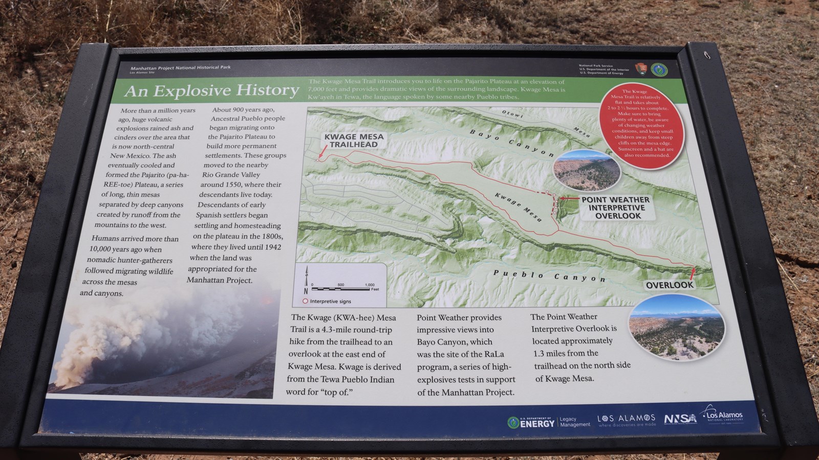
An Explosive History – The Kwage Mesa Trail introduces you to life on the Pajarito Plateau at an elevation of 7,000 feet and provides dramatic views of the surrounding landscape. Kwage Mesa is Kw’ayeh in Tewa, the language spoken by some nearby Pueblo tribes.
More than a million years ago, huge volcanic explosions rained ash and cinders over the area that is now north-central New Mexico. The ash eventually cooled and formed the Pajarito (pa-ha-REE-toe) Plateau, a series of long, thin mesas separated by deep canyons created by runoff from the mountains to the west.
Humans arrived more than 10,000 years ago when nomadic hunter-gatherers followed migrating wildlife across the mesas and canyons.
About 9,000 years ago, Ancestral Pueblo people began migrating onto the Pajarito Plateau to build more permanent settlements. These groups moved to the nearby Rio Grande Valley around 1550, where their descendants live today. Descendants s of early Spanish settlers began settling and homesteading on the plateau in the 1800s, where they lived until 1942 when the land was appropriated for the Manhattan Project
The Kwage (KWA-hee) Mesa Trail is a 4.3-mile (6.9 km) round-trip hike from the trailhead to an overlook at the east end of Kwage Mesa. Kwage is derived from the Tewa Pueblo Indian word for “top of.”
Point Weather provides impressive views into Bayo Canyon, which was the site of the RaLa program, a series of high-explosives tests in support of the Manhattan Project.
Point Weather Interpretive Overlook is located approximately 1.3 miles (2.09 km) from the trailhead on the north side of Kwage Mesa.
In a red circle on the top right corner it says, “The Kwage Mesa Trail is relatively flat and takes about 2 to 2 ½ hours to complete. Make sure to bring plenty of water, be aware of changing weather conditions, and keep small children away from steep cliffs on the mesa edge. Sunscreen and a hat are also recommended.
Exhibit Panel Description
A black band at the top of the wayside says, “Manhattan Project National Historical Park Los Alamos, New Mexico” On the right of the black band is the National Park Service log o and the U.S. Department of Energy logo. Below the black band a green band has the title of this wayside, “An Explosive History.” The largest image is a map of the trail with the “Kwage Mesa Trailhead” to the left of the loop and “Point Weather Interpretive Overlook” in the middle of the trail and “Overlook” to the right. The trail is on a mesa between two canyons that are labeled, “Bayo Canyon” to the north and “Pueblo Canyon” to the south. The bottom left corner has an image of a volcano exploding. A blue bar at the bottom has “U.S. Department of Energy | Legacy Management, Los Alamos Where Discoveries Are Made, NNSA, and Los Alamos National Laboratory.”
Visit This Exhibit Panel
The Kwage Mesa stretches out on the north side of Los Alamos. From 15th Street and Central Avenue in downtown Los Alamos, head west (towards the Jemez Mountains) on Central. In 0.8 miles (1.28 km), past Ashley Pond, and the Aquatic Center, turn right onto Diamond Drive. Pass the Los Alamos High School and the Los Alamos Golf Course to the San Ildefonso roundabout located 2.4 miles (3.86 km) from the intersection of Central and Diamond. Bear right on San Ildefonso. Head south, then east on this road, passing the Los Alamos Middle School. About 0.1-mile (0.16 km) past North Mesa Road on the left, turn left onto an unnamed road heading toward the stable area. The road swings to the right and ends at a parking area at the North Mesa Tennis Courts. The trailhead is on the left of the playlot.