Last updated: October 5, 2022
Place
Los Alamos Wayside: Cleaning Up Bayo Canyon
NPS
Quick Facts
Location:
Kwage Mesa Trail
MANAGED BY:
Amenities
1 listed
Historical/Interpretive Information/Exhibits
Main Text
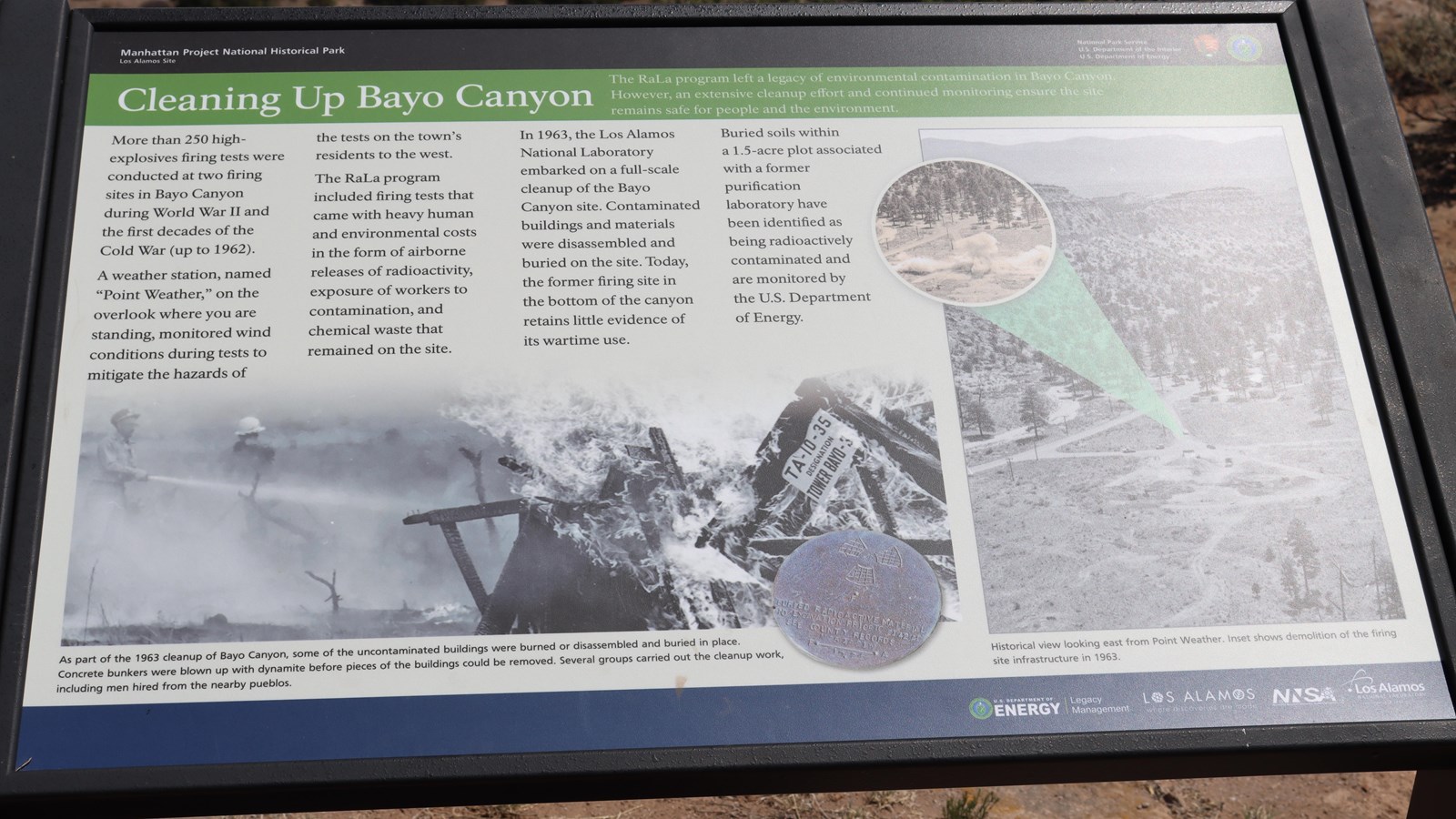
Cleaning Up Bayo Canyon – The RaLa program left a legacy of environmental contamination in Bayo Canyon. However, an extensive cleanup effort and continued monitoring ensure the site remains safe for the people and the environment.
More than 250 high-explosives firing tests were conducted at two firing sites in Bayo Canyon during World War II and the first decades of the Cold War (up to 1962). A weather station, named “Point Weather,” on the overlook where you are standing, monitored wind conditions during tests to mitigate the hazards the tests on the town’s residents to the west. The RaLa program included firing tests that came with heavy human and environmental costs in the form of airborne releases of radioactivity, exposure of workers to contamination, and chemical waste that remained on the site. In 1963, the Los Alamos National Laboratory embarked on a full-scale cleanup of the Bayo Canyon site. Contaminated buildings and materials were disassembled and buried on the site. Today, the former firing site at the bottom of the canyon retains little evidence of its wartime use. Buried within a 1.5-acre plot associated with former purification laboratory have been identified as being radioactivity contaminated and are monitored by the U.S. Department of Energy.
Exhibit Panel Description
A black band at the top of the wayside says, “Manhattan Project National Historical Park Los Alamos, New Mexico” On the right of the black band is the National Park Service log o and the U.S. Department of Energy logo. Below the black band a green band has the title of this wayside, “Cleaning Up Bayo Canyon.” An image along the bottom of the wayside has people spraying hoses on a fire, a silver medallion in the bottom of the image says, “Burned radioactive material no excavation prior to 142 AD see county records.” The caption for this image reads, “As part of the 1963 cleanup of Bayo Canyon, some of the uncontaminated buildings were burned or disassembled and buried in place. Concert bunkers were blown up with dynamite before pieces of the buildings could be removed. Several groups carried out the cleanup work, including men hired from the nearby pueblos. A second image is a black and white image of a view of the Bayo Canyon from above and a zoomed in circle of smoke. The caption for this image reads, “Historical view looking east from Point Weather. Insert shows demolition of the firing site infrastructure in 1963.” A blue bar at the bottom has “U.S. Department of Energy | Legacy Management, Los Alamos Where Discoveries Are Made, NNSA, and Los Alamos National Laboratory.”
Visit This Exhibit Panel
This wayside is located along the Kwage Mesa Trail. The Kwage Mesa stretches out on the north side of Los Alamos. To get to the trailhead from 15th Street and Central Avenue in downtown Los Alamos, head west (towards the Jemez Mountains) on Central. In 0.8 miles (1.28 km), past Ashley Pond, and the Aquatic Center, turn right onto Diamond Drive. Pass the Los Alamos High School and the Los Alamos Golf Course to the San Ildefonso roundabout located 2.4 miles (3.86 km) from the intersection of Central and Diamond. Bear right on San Ildefonso. Head south, then east on this road, passing the Los Alamos Middle School. About 0.1-mile (0.16 km) past North Mesa Road on the left, turn left onto an unnamed road heading toward the stable area. The road swings to the right and ends at a parking area at the North Mesa Tennis Courts. The trailhead is on the left of the playlot.