Last updated: October 11, 2022
Place
Los Alamos Wayside: Pueblo Communities
NPS
Quick Facts
Location:
Kwage Mesa Trail
MANAGED BY:
Amenities
1 listed
Historical/Interpretive Information/Exhibits
Main Text
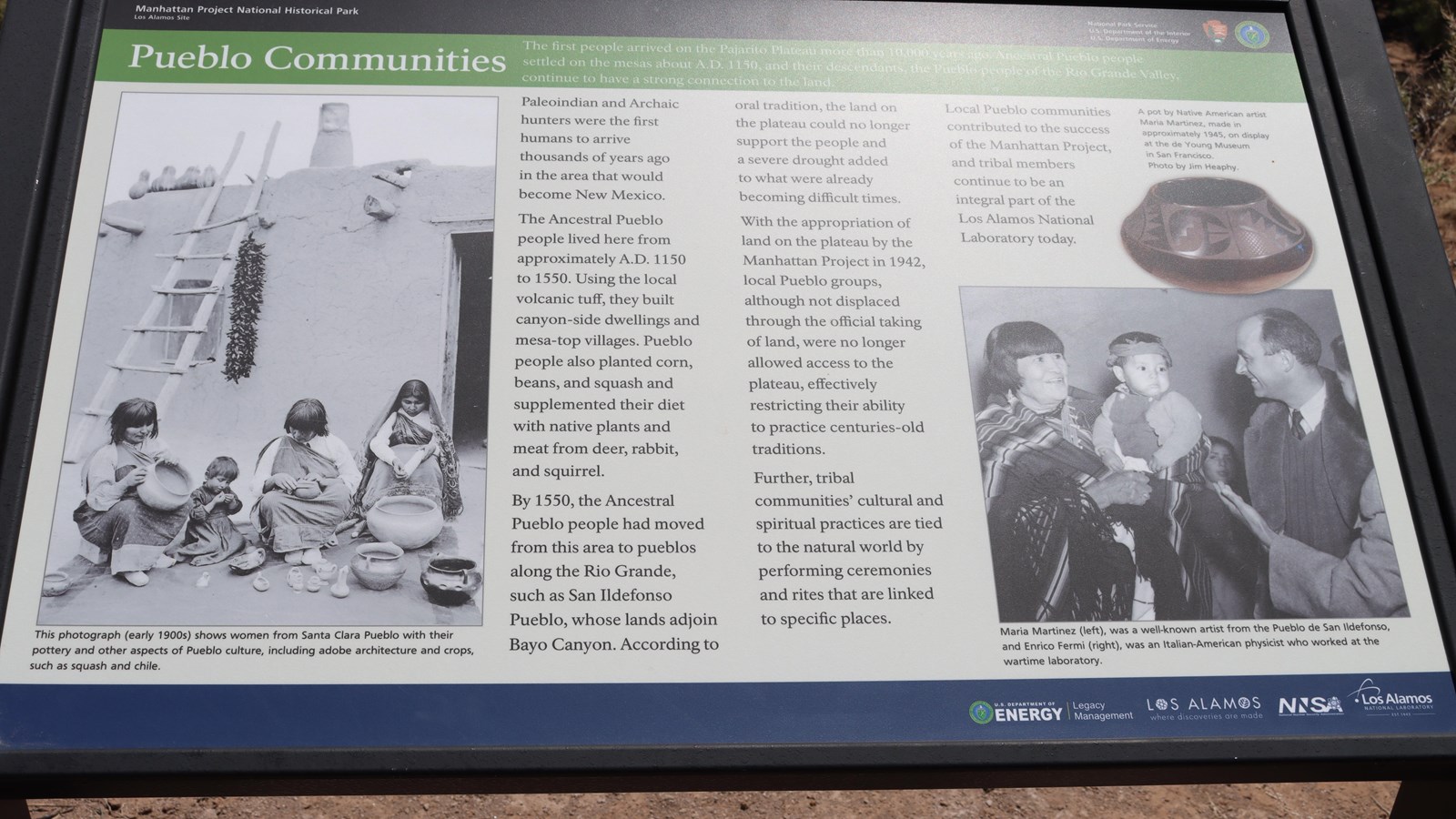
Pueblo Communities – The first people arrived on the Pajarito Plateau more than 10,000 years ago. Ancestral Pueblo settled on the mesas about A.D. 1150, and their descendants, the Pueblo people of the Rio Grande Valley, continue to have a strong connection to the land.
Paleoindian and Archaic hunters were the first humans to arrive thousands of years ago in the area that would become New Mexico. The Ancestral Pueblo people lived here from approximately A.D. 1150 to 1550. Using the local volcanic tuff, they built canyon-side dwellings and mesa-top villages. Pueblo people also planted corn, beans, and squash and supplemented their diet with native plants and meat from deer, rabbit, and squirrel. By 1550, the Ancestral Pueblo people had moved from this area to pueblos along the Rio Grande, such as San Ildefonso Pueblo, whose lands adjoin Bayo Canyon. According to oral tradition, the land on the plateau could no longer support the people and a severe drought added to what were already becoming difficult times. With the appropriation of land on the plateau by the Manhattan Project in 1942, local Pueblo groups, although not displaced through the official taking of land, were no longer allowed access to the plateau, effectively restricting their ability to practices centuries-old traditions. Further, tribal communities’ cultural and spiritual practices are tied to the natural world by performing ceremonies and rites that are linked to specific places. Local Pueblo communities contributed to the success of the Manhattan Project, and tribal members continue to be an integral part of the Los Alamos National Laboratory today.
Exhibit Panel Description
A black band at the top of the wayside says, “Manhattan Project National Historical Park Los Alamos, New Mexico” On the right of the black band is the National Park Service logo and the U.S. Department of Energy logo. Below the black band a green band has the title of this wayside, “Pueblo Communities.” On the left a large black and white photo of four people sitting outside an adobe house with a wooden ladder leading to the roof. The four people are working on clay pottery. Text below the image reads, “This photograph (early 1900s) shows women from Santa Clara Pueblo with their pottery and other aspects of Pueblo culture, including architecture and corps, such as squash and chile.” On the right side of the wayside an image of clay pottery. The text above the clay pottery reads, “A pot by Native American artists Maria Martinez, made in approximately 1945, on display at the de Young Museum in San Francisco. Photo by Jim Heaphy.” Below the oval a black and white photo of a woman with dark hair hold a child while a man in a vest and fur coat smiles at the kid. Below the image the text reads, “Maria Martinez (left), was a well-known artist from the Pueblo de San Ildefonso, and Enrico Fermi (right), was an Italian-American physicist who worked at the wartime laboratory.” A blue bar at the bottom has “U.S. Department of Energy | Legacy Management, Los Alamos Where Discoveries Are Made, NNSA, and Los Alamos National Laboratory.”
Visit This Exhibit Panel
This wayside is located along the Kwage Mesa Trail. The Kwage Mesa stretches out on the north side of Los Alamos. To get to the trailhead from 15th Street and Central Avenue in downtown Los Alamos, head west (towards the Jemez Mountains) on Central. In 0.8 miles (1.28 km), past Ashley Pond, and the Aquatic Center, turn right onto Diamond Drive. Pass the Los Alamos High School and the Los Alamos Golf Course to the San Ildefonso roundabout located 2.4 miles (3.86 km) from the intersection of Central and Diamond. Bear right on San Ildefonso. Head south, then east on this road, passing the Los Alamos Middle School. About 0.1-mile (0.16 km) past North Mesa Road on the left, turn left onto an unnamed road heading toward the stable area. The road swings to the right and ends at a parking area at the North Mesa Tennis Courts. The trailhead is on the left of the playlot.