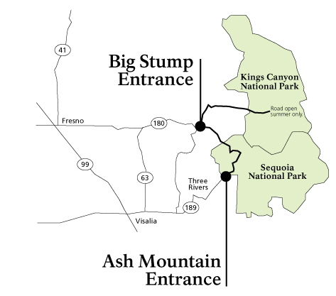
Driving in Sequoia & Kings Canyon National ParksRoads here are steep, winding, and narrow. Vehicle length limits and advisories are in place on many park roads, including the Generals Highway from the foothills to Giant Forest. No gasoline is available in the national parks, though nearby national forests have gas stations. During snowy weather, tire chains may be required to drive park roads. To help plan your route, check our driving map of the parks and regional maps of the area. 
No FuelThere are no gas stations or chargers within park boundaries, though there are limited, seasonal stations on nearby national forest lands. Electric vehicle charging stations may be available near the parks. Roads to Sequoia & Kings Canyon
|
|
City |
Distance |
Time |
Directions |
|---|---|---|---|
|
Fresno |
60 mi/97 km |
1 hour, 15 minutes |
Take CA-180 E to the Big Stump entrance of Kings Canyon National Park. |
|
San Fransisco |
250 mi/402 km |
4 hours, 30 minutes |
Take I-80 E to I-580 E. Continue onto I-205 E, merge onto I-5 N. Take CA-120 E to CA-99 S. Then take exit 133B onto CA-180 E. Continue to the Big Stump entrance of Kings Canyon National Park. |
|
San Jose |
217 mi/349 km |
4 hours |
Take CA-85 S and merge onto US-101 S. Take exit 356 onto CA-152 E. Take CA-99 S. Take exit 133B onto CA-180 E. Continue to the Big Stump entrance of Kings Canyon National Park. |
|
Sacramento |
240 mi/386 km |
4 hours, 15 minutes |
Take US-50 E/CA-99 S towards Fresno. Take exit 133B onto CA-180 E. Continue to the Big Stump entrance of Kings Canyon National Park. |
|
Reno |
365 mi/587 km |
6 hours, 30 minutes |
Take I-80 W towards Sacramento. In Sacramento, take CA-99S. In Fresno, take exit 133B onto CA-180 E. Continue to the Big Stump entrance of Kings Canyon National Park. |
|
Lake Tahoe |
330 mi/531 km |
6 hours |
From South Lake Tahoe take US-50 W towards Sacramento. In Sacramento, take CA-99S. In Fresno, take exit 133B onto CA-180 E. Continue to the Big Stump entrance of Kings Canyon National Park. |
|
Yosemite Entrance |
130 mi/209 km |
2 hours, 30 minutes |
Take CA-41 S toward Fresno. In Fresno, take exit 128 onto CA-180 W. Merge onto CA-180 E. Continue to the Big Stump entrance of Kings Canyon National Park. |
To Sequoia National Park's Ash Mountain Entrance (Highway 198)
|
City |
Distance |
Time |
Directions |
|---|---|---|---|
|
Visalia |
36 mi/58 km |
45 minutes |
Take CA-198 E to the Ash Mountain entrance of Sequoia National Park. |
|
Los Angeles Area |
225 mi/362 km |
4 hours |
Take any highway to I-5 N. Continue onto CA-99 N toward Bakersfield/Fresno. Take exit 96 onto CA-198 E towards Visalia. Continue to the Ash Mountain entrance of Sequoia National Park. |
|
San Diego Area |
344 mi/538 km |
5 hours, 50 minutes |
Take I-805 N or I-5 N to CA-99N toward Bakersfield/Fresno. Take exit 96 onto CA-198 E towards Visalia. Continue to the Ash Mountain entrance of Sequoia National Park. |
|
Las Vegas |
400 mi/644 km |
6 hours, 30 minutes |
Take I-15 S towards Los Angeles. Take exit 179 onto CA-58 W towards Bakersfield. In Bakersfield, continue onto CA-99 N toward Fresno. Take exit 96 onto CA-198 E towards Visalia. Continue to the Ash Mountain entrance of Sequoia National Park. |
|
Death Valley National Park (West Entrance) |
310 mi/499 km |
5 hours 25 min |
CA-190 W to US-395 S and turn left. Continue onto CA-14S. Turn right at CA-58 W. Take the ramp onto CA-99 N. Take exit 96 onto CA-198 E towards Visalia. Continue to the Ash Mountain entrance of Sequoia National Park. |
Last updated: September 4, 2025


