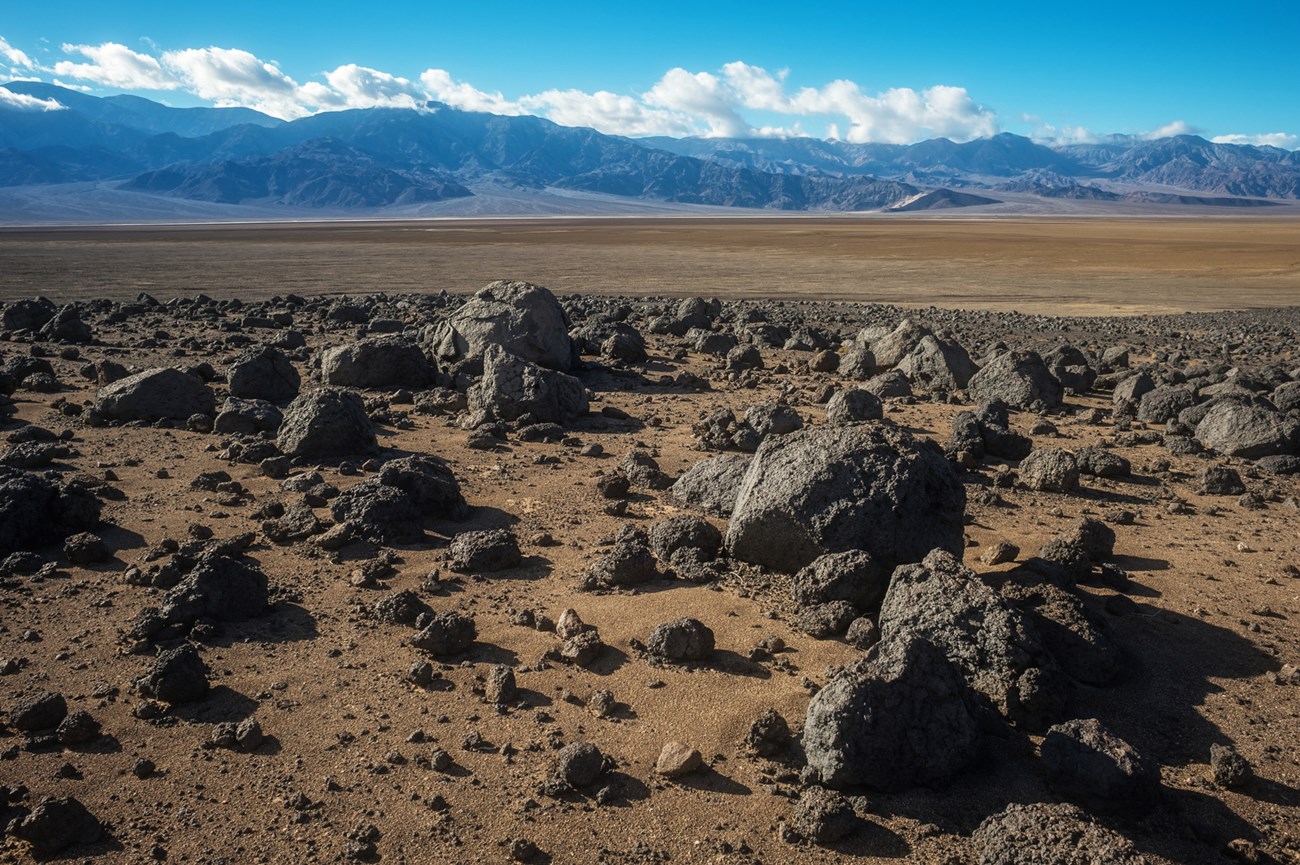
NPS photo by Kurt Moses.
Geology and Stratigraphy of the Mojave Desert I&M Network
The Mojave Desert Inventory & Monitoring Network (MOJN) consists of seven national park units in southern California, Nevada, and northwestern Arizona. These parks include: Death Valley National Park (DEVA), Great Basin National Park (GRBA), Joshua Tree National Park (JOTR), Lake Mead National Recreation Area (LAKE), Manzanar National Historic Site (MANZ), Mojave National Preserve (MOJA), and Grand Canyon-Parashant National Monument (PARA). Additionally, there are two units geographically within the MOJN that were established after the creation of the Inventory & Monitoring program: Castle Mountains National Monument (CAMO) and Tule Springs Fossil Beds National Monument (TUSK). We are including them in this report as appropriate, although they are not officially considered I&M parks.Most of the parks in the MOJN are located within or very near the Mojave Desert, hence the name of the network. GRBA is the major outlier. The Mojave Desert is related to the Great Basin physiographic province and the Basin and Range tectonic province. The desert overlaps the southern part of the Great Basin, known for its internal drainage. In turn, the Mojave Desert and Great Basin overlap a significant part but not all of the Basin and Range tectonic province. The Basin and Range province is characterized by high elevation fault-block mountain chains and intermountain flat-lying basins that began to develop during the early Miocene. Among these basins, the lowest elevation point in the United States is recorded at Badwater in DEVA. The MOJN also includes a small portion of the southwestern Colorado Plateau, where PARA is located.
Geologically, the MOJN parks collectively preserve an extensive rock record spanning from the Paleoproterozoic through the Holocene (see geologic time scale). A complex geologic history includes marine and terrestrial sedimentary rocks, extrusive and intrusive igneous rocks and metamorphic rocks. The geologic features and processes of the Basin and Range province present iconic and scenic landscapes within the MOJN parks.
A Brief Geologic History
A few examples of events and Network resources in each geologic time period are highlighted below, from youngest to oldest.
The oldest Paleogene units in the MOJN include the late Eocene through early Oligocene Titus Canyon Formation at DEVA. At GRBA igneous dikes, sills and a biotite granite are referenced to be either Eocene or Oligocene in age. Additionally, rhyodacite flows and subvolcanic intrusive rocks at GRBA are reported to date to the early Oligocene. The Ubehebe Formation in DEVA spans from the late Oligocene to the early Miocene. Additionally, the Rainbow Gardens Formation in PARA is a late Oligocene to early Miocene unit.
The Miocene, especially the late Miocene, is well represented by rock units in the MOJN parks. The oldest known Miocene unit is the Horse Spring Formation at LAKE which spans the early to middle Miocene with several members. Early Miocene tuffs and unnamed sedimentary rocks are also found at MOJA. During the middle to late Miocene there was both extrusive and intrusive igneous activity as evidenced by rocks exposed within CAMO, LAKE, MOJA and PARA. A number of middle to late Miocene formations are mapped in DEVA including the Artist Drive, Eagle Mountain, and Furnace Creek Formations. The Hualapai Limestone and Muddy Creek Formation are mapped in LAKE. Additionally, the “Rocks of the Overton Arm” and the “Rocks of the Grand Wash Trough” span the middle and late Miocene at LAKE. The “Rocks of the Grand Wash Trough” also occur at PARA. The Cima volcanic field at MOJA became active during the late Miocene.
Pliocene rocks include a number of named formations in DEVA including the Greenwater Volcanics, Copper Canyon Formation, and Funeral Formation, along with a variety of volcanic units. At LAKE the Pliocene is represented by the Bouse Formation, along with the “Deposits of Hualapai Wash” and Deposits at Jumbo Pass”. A number of unnamed Pliocene units occur in MOJN parks.
The oldest Mesozoic unit known in the MOJN parks is the Early–Middle Triassic Moenkopi Formation which is mapped in LAKE, MOJA and PARA. Unnamed Middle Triassic intrusive igneous rocks occur at JOTR. The Late Triassic Chinle Formation is exposed in LAKE and PARA.
The Butte Valley Formation at DEVA is an Early Jurassic marine unit. The Early Jurassic Moenave and Kayenta Formations are mapped in LAKE and PARA. The Early Jurassic Aztec Sandstone is mapped in two of the MOJN parks, LAKE and MOJA, while the time-equivalent Navajo Sandstone is mapped in PARA, the Colorado Plateau park. A variety of Jurassic intrusive rocks occur within GRBA, JOTR, and MOJA. 6 The McCoy Mountains Formation is a possible Early Cretaceous unit in JOTR. Late Cretaceous igneous rocks, both intrusive and extrusive, are mapped at DEVA, GRBA, JOTR, LAKE, and MOJA.
The Paleozoic is well represented throughout the parks of the MOJN. The transition between Proterozoic and early Cambrian is preserved in several parks of the network. The Cambrian marks a worldwide event in the history of life referred to as the “Cambrian Explosion”. This transition is marked by an abundant fossil record preserved with the first organisms incorporating calcium carbonate exoskeletons. The Waucoban Series in DEVA was studied and defined by paleontologist Charles Walcott during the late 1890s, and is the reference section for this earliest Cambrian diversification of life. A large number of early Cambrian units are mapped in DEVA, including the Wood Canyon Formation, Zabriskie Quartzite, Poleta Formation, and other units. The Wood Canyon Formation and Zabriskie Quartzite are also mapped in MOJA, along with the Latham Shale and other early Cambrian units. The Prospect Mountain Quartzite marks the Proterozoic–Cambrian transition at GRBA.
The early–middle Cambrian is preserved by the Tapeats Sandstone in LAKE. The middle Cambrian Bright Angel Shale and Muav Limestone are mapped in both LAKE and PARA. At DEVA, the middle Cambrian is represented by the Carrara and Bonanza King Formations. The Bonanza King Formation is also present in MOJA. The late Cambrian Nopah Formation is exposed in DEVA and 5 MOJA. At GRBA the late Cambrian is represented by several formations including the House Limestone which spans into the Early Ordovician.
At DEVA, GRBA, and LAKE the Early and Middle Ordovician are recorded in the Pogonip Group. The Eureka Quartzite dates to the Late Ordovician at DEVA and GRBA.
The Silurian is documented in the Ely Springs Dolomite and Hidden Valley Dolomite within DEVA. There are also some unnamed Silurian rocks on Bullfrog Mountain in DEVA.
The Hidden Valley Formation extends into the Early Devonian in DEVA. The Lost Burro Formation spans the Early to Late Devonian at DEVA. The Early Devonian at GRBA is marked by the Sevy Dolomite, overlain by the Simonson Dolomite and Guilmette Formation. Middle to Late Devonian units include the Sultan Formation, mapped in western LAKE and MOJA, and the Temple Butte Formation, mapped in eastern LAKE and PARA.
Mississippian-age rocks are preserved in DEVA, LAKE, MOJA and PARA. The Early Mississippian is mapped in DEVA with the Tin Mountain Limestone. The Early–Middle Redwall Limestone occurs within LAKE and PARA. At MOJA the Monte Cristo Formation represents the Early–Middle Mississippian. The Perdido Group, Learning Rock Formation and Mexican Spring Formation mark the Early and Middle Mississippian in DEVA, and the Rest Spring Shale and Indian Springs Formation mark the Late Mississippian. At LAKE and PARA several Late Mississippian formations of the Supai Group are mapped and extend into the Pennsylvanian. The Pennsylvanian at DEVA and MOJA is represented by the Bird Spring Formation.
The early Permian is exposed in four MOJN parks: DEVA, LAKE, MOJA, and PARA. The Bird Spring Formation spans from the Pennsylvanian into the early Permian in DEVA and MOJA. The Keeler Canyon Formation also extends from the Pennsylvanian into the Permian at DEVA. Additional early Permian units at DEVA include the Osborne Canyon Formation, Darwin Canyon Formation, Lone Pine Formation, Upland Valley Limestone, and Owens Valley Group. At LAKE and PARA the early Permian is represented by the Pakoon Limestone, Esplanade Sandstone, Hermit Shale, Coconino Sandstone, Toroweap Formation, and Kaibab Limestone.
Rocks of Precambrian age (in the informal sense of “older than the Cambrian”) are well exposed and documented within several parks of the MOJN and span much of the Proterozoic Eon. Paleoproterozoic and Mesoproterozoic igneous and metamorphic rocks occur at CAMO, DEVA, JOTR, LAKE and MOJA. The Neoproterozoic is represented in DEVA, from oldest to youngest, by the Pahrump Group, Johnnie Formation, Sterling Quartzite and the lower portion of the Wood Canyon Formation. At GRBA the Neoproterozoic units include the McCoy Creek Group and the lower portion of the Prospect Mountain Quartzite. At MOJA, pre-Johnnie Formation sedimentary rocks, Johnnie Formation, Stirling Quartzite and the lower portion of the Wood Canyon Formation are Neoproterozoic in age.
Geology & Soils—Mojave Desert Network Parks
Type Sections—Mojave Desert Network

The geologic history above is excerpted from a report titled, "National Park Service geologic type section inventory: Mojave Desert Inventory & Monitoring Network". Type sections are essential reference locations for the geoscientists who study geologic history and paleontology. A summary of the type sections in each park can be found at the links below.
-
Death Valley National Park, California and Nevada (contains 45 identified stratotypes)
-
Grand Canyon-Parashant National Monument, Arizona (two designated stratotypes identified)
-
Great Basin National Park, Nevada (contains six identified stratotypes)
-
Joshua Tree National Park, California (no designated stratotypes identified)
-
Lake Mead National Recreation Area, Nevada and Arizona (contains two identified stratotypes)
-
Manzanar National Historic Site, California (no designated stratotypes identified)
-
Mojave National Preserve, California (contains two identified stratotypes)
-
Tule Springs Fossil Beds National Monument, Nevada (currently, no designated stratotypes*)
The full Network report is available in digital format from:
Please cite this publication as:
-
Henderson TC, Santucci VL, Connors T, Tweet J. 2021. National Park Service geologic type section inventory: Mojave Desert Inventory & Monitoring Network. Natural Resource Report. National Park Service. Fort Collins, Colorado.
NPS Stratotype Inventory
Fossil Resources—Mojave Desert Network

Between 2002 and 2011, network-based paleontological resource inventories were completed for all the 32 I&M networks, and six of the earliest were completely updated between 2012 and 2016. The report linked below summarizes the paleontological resources of all park units in the Mojave Desert Inventory & Monitoring Network (MOJN). The report provides geologic background and paleontological resource data for each park to support management operations, planning, and science-based decision making as required by NPS management policies and the Paleontological Resources Preservation Act (2009).
The full report is available in digital format from
Please cite this publication as:
-
Tweet JS, Santucci LV, Connors T. 2016. Paleontological resource inventory and monitoring: Mojave Desert Network. Natural Resource Report. NPS/MOJN/NRR—2016/1209. National Park Service. Fort Collins, Colorado.
Geodiversity Atlas pages—by Inventory & Monitoring Network
Arctic Network Index
Central Alaska Network Index
Chihuahuan Desert Network Index
Cumberland Piedmont Network Index
Eastern Rivers and Mountains Network Index
Great Lakes Network Index
Greater Yellowstone Network Index
Gulf Coast Network Index
Heartland Network Index
Klamath Network Index
Mediterranean Coast Network Index
Mid-Atlantic Network Index
Mojave Desert Network Index
National Capital Network Index
North Coast and Cascades Network Index
Northeast Coastal and Barrier Network Index
Northeast Temperate Network Index
Northern Colorado Plateau Network Index
Northern Great Plains Network Index
Pacific Islands Network Index
Rocky Mountain Network Index
San Francisco Bay Area Network Index
Sierra Nevada Network Index
Sonoran Desert Network Index
South Florida/Caribbean Network Index
Southeast Alaska Network Index
Southeast Coast Network Index
Southern Colorado Plateau Network Index
Southern Plains Network Index
Southwest Alaska Network Index
Upper Columbia Basin Network Index
Geodiversity Atlas pages—by State, U.S. Commonwealth, and Territories
Alabama | Alaska | Arizona | Arkansas | California | Colorado | Connecticut | District of Columbia | Delaware | Florida | Georgia | Hawaii | Idaho | Illinois | Indiana | Iowa | Kansas | Kentucky | Louisiana | Maine | Maryland | Massachusetts | Michigan | Minnesota | Mississippi | Missouri | Montana | Nebraska | Nevada | New Hampshire | New Jersey | New Mexico | New York | North Carolina | North Dakota | Ohio | Oklahoma | Oregon | Pennsylvania | Rhode Island | South Carolina | South Dakota | Tennessee | Texas | Utah | Vermont | Virginia | Washington | West Virginia | Wisconsin | Wyoming
U.S. Commonwealth and Territories
Region 2: South Atlantic-Gulf (Includes Puerto Rico and the U.S. Virgin Islands)
Region 3: Great Lakes
Region 4: Mississippi Basin
Region 5: Missouri Basin
Region 6: Arkansas-Rio Grande-Texas-Gulf
Region 7: Upper Colorado Basin
Region 8: Lower Colorado Basin
Region 9: Columbia-Pacific Northwest
Region 10: California-Great Basin
Region 11: Alaska
Region 12: Pacific Islands (American Samoa, Hawaii. Guam, Commonwealth of the Northern Mariana Islands)
Last updated: February 21, 2025
