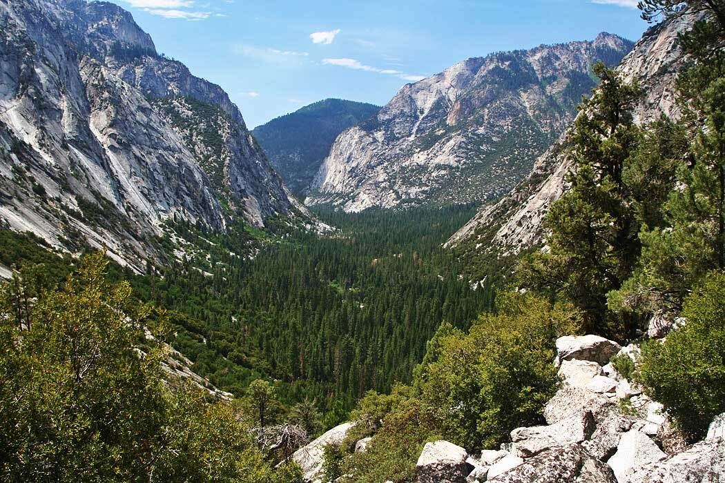
NPS photo by Rick Cain.
Geology and Stratigraphy of the Sierra Nevada I&M Network
The Sierra Nevada Inventory & Monitoring Network (SIEN) consists of three parks: Devils Postpile National Monument (DEPO), Sequoia & Kings Canyon National Parks (SEKI), and Yosemite National Park (YOSE). These parks are situated within the Sierra Nevada, a mountain range that extends north to south approximately 640 km (400 mi) along eastern California. To the east is the Basin and Range Province and to the west is the Great Valley Province of California. The Sierra Nevada is an asymmetrical range, with the peaks of highest elevation on the eastern flank. SEKI includes the tallest mountain in the continental United States (Mount Whitney), which rises to 4,421 m (14,505 ft) above sea level. YOSE contains two dozen peaks which reach more than 3,660 m (12,000 ft) in elevation, the highest of which is Mount Lyell at 3,997 m (13,114 ft) above sea level.Geologically, the bedrock geology of the SIEN parks is dominated by granitic rocks formed during the Mesozoic. These rocks make up a batholith, an enormous igneous intrusion composed of numerous smaller bodies (plutons), in this case representing the backbone of the Sierra Nevada range (see geologic time scale). The Mesozoic granitic magmas intruded older metamorphic rocks which are present as belts adjacent to, and also as engulfed fragments within the batholith. Overlying the granitic and metamorphic basement rocks in places are younger Cenozoic-age volcanic and sedimentary rocks. The Sierra Nevada is a massive uplifted and westward-tilted block of crust. This uplift occurred over the past several million years. The eastern edge of the uplifted mountains is an escarpment which has been heavily eroded by ice and water, forming a series of steep canyons. The western flank is a more gently dipping slope with alluvial fan development toward the Central Valley.
During the Pleistocene Epoch glaciers formed in the Sierra Nevada and sculpted the geologic landscape. Many valleys were carved by glaciers into the famous U-shaped valleys and hanging valleys prominent in Yosemite Valley in YOSE. Large cirques, many glacial lakes and extensive accumulations of moraines are all evidence of past glacial activity in the parks of the SIEN. Glacial striations are seen in all the SIEN parks; the glacial polish and striations atop the columnar jointing are iconic features at DEPO.
A Brief Geologic History
A few examples of events and Network resources in each geologic time period are highlighted below, from youngest to oldest.
There are no exposed Cenozoic-age plutonic rocks in the Sierra Nevada batholith. Originally the batholith was formed at considerable depth and was covered by older Paleozoic and Mesozoic rock sequences. Today nearly all the Paleozoic and Mesozoic metamorphic rocks have been removed through erosion, leaving only some isolated screens and pendants. A sequence of Pliocene volcanics occur in SEKI, along with surficial Quaternary sediments and alluvium.
Glaciation at SEKI was not as extensive as at YOSE. However, the landscape has been influenced and shaped by the action of alpine glaciers. The development of glaciers in the southern Sierra began early, perhaps during the Late Pliocene. The river valleys on the western slope were transformed through glacier scouring to form typical U-shaped topography. The impacts of glaciation are more evident in Kings Canyon National Park than in Sequoia National Park. A period of renewed glacial development is documented at Kings Canyon National Park during the Little Ice Age (1450–1850 7 AD), when glaciers were re-established in Pleistocene cirques. Small valley glaciers also advanced near Mount Goddard and in the Palisades region along the northeast boundary of the park.
Regionally, there was volcanic activity during the Late Cenozoic. Most of the volcanic rocks of this period occur outside of the park boundaries except for some exposures north of the Grand Canyon of the Tuolumne River. These units are largely andesitic and include some lahar deposits (volcanic mudflows). As the Sierra Nevada was uplifted, a western and southwestern drainage pattern developed. The Merced River and other rivers incised into the western slopes of the mountains and eventually developed into broad river valleys. The drainage of tributaries to the Merced River proceeded at different rates and traversed rocks of varying hardness and resistance to erosion. As a result, waterfalls began to develop in the tributaries, such as Bridalveil Creek, which crossed more resistant rock.
By the Pleistocene, Yosemite Valley was a deep and V-shaped river valley with steep ridges dividing the tributary drainages. Pleistocene glacial activity dramatically altered its surface features and topography. Differential downcutting by tributary drainages resulted in the development of waterfalls emerging from the hanging valleys. Severe erosion occurred during advances within each of the four stages of glacial activity identified in YOSE (youngest to oldest): Sherwin, Tahoe, Tenaya, and Tioga. The earlier stages were longer and resulted in greater amounts of erosion. Most of the evidence of the Sherwin Glacial Stage was destroyed by younger stages. Tahoe Glacial Stage moraines indicate that glaciation extended a few kilometers west of El Portal near the park entrance. The Graveyard Glacial Stage advanced to the base of Bridalveil Falls. The Tioga Glacial Stage is the most recent of the glacial advances and is represented by the most extensive and undissected moraines.
Yosemite’s Pleistocene glaciers were extremely thick and largely re-shaped Yosemite Valley. They rounded the V-shaped river valley to a classic U-shaped glacial valley floor. Glaciers further excavated and sculptured the area to form giant staircases and hanging valleys within the tributary valleys. Many of the famous waterfalls cascade over the staircases or dramatically drop, sometimes several hundred feet, from the locations where the hanging valleys open into Yosemite Valley. Glacial deposits and other evidence of the glacial activity can be found throughout the park. The last glacier retreated from Yosemite Valley approximately 15,000 years ago, depositing significant amounts of alluvial outwash, glacial debris and moraine material. Lake Yosemite temporarily developed behind the glacial deposits. The floor of Yosemite Valley is blanketed with approximately 610 m (2,000 ft) of alluvium. Glacial deposits and other evidence of the glacial activity can be found throughout the park. Today nearly 25 small glaciers occur within the park. During the last 3,000 to 4,000 years, groves of giant sequoia trees have been re-established in isolated areas along the western slopes of the Sierra Nevada, after being nearly extirpated by the widespread and successive Pleistocene glaciations. The giant sequoias have an affinity for sandy loam soils derived from granitic rock.
The Cenozoic geology of DEPO is dominated by a thick sequence of Quaternary volcanic flows, which includes the park’s notable columnar basalts. Volcanism is associated with faulting in the eastern Sierra Nevada beginning approximately 3 million years ago. The oldest volcanic rocks in or 8 near Devils Postpile are Quaternary basalt flows which date to about 82,000 years ago (Hildreth et al. 2014). The proposed source of the lava is near the Upper Soda Springs Campground, at the north end of Pumice Flat on the floor of the Middle Fork of the San Joaquin River. The lava flow appears to have been impounded by moraines and accumulated to a thickness of approximately 120 m (400 ft). Basalt flows at DEPO exhibit specialized fracturing (columnar joints) which occurred during the cooling and crystallization of the lava and divided it into tall polygonal columns or pillars. More recent Pleistocene glaciation eroded and removed large portions of the volcanic rocks, exposing the columnar basalts at DEPO and leaving a veneer of glacial polish.
The Mesozoic history of SEKI is represented by Triassic and Jurassic metasedimentary and metavolcanic rocks preserved as screens (remnants of the original intruded rock). The Mesozoic metamorphic rocks are well-exposed in the canyons of Kings River and Kaweah River, as well as in the Mineral King portion of the park. These rock units consist of marbles, schists, and cherts which are found in association with metavolcanic rocks. Many of the SEKI caves are formed within the Mesozoic marbles exposed in the park. During the Cretaceous, plutonic (intrusive igneous) activity was widespread in the Sierra Nevada. The Sierra Nevada batholith plutons were emplaced in a complex series of episodic events (Bateman 1992). The older granitic rocks have been dated from the western portion of the park and the younger granitic rocks were determined to be near the crest of the Sierra Nevada. The older intrusive rocks have a more mafic composition such as quartz diorite.
At YOSE, erosion has removed most of the Paleozoic and Jurassic rocks directly above the batholith. During the Early Cretaceous a series of widespread and complex igneous intrusion events occurred throughout the region. Within what is now Yosemite Valley, a series of magmas intruded the Paleozoic and Mesozoic sequences that belong to the Yosemite Valley Intrusive Suite and Fine Gold Intrusive Suite. The youngest of the Cretaceous intrusive events are represented by the Tuolumne Intrusive Suite. Together these suites consist of several units named after iconic geologic features of the park, including El Capitan Granite, Taft Granite, Granodiorite of Arch Rock, Sentinel Granodiorite, Half Dome Granodiorite, and Cathedral Peak Granodiorite. A total of eight separate intrusive suites are situated in YOSE and represent major events associated with the emplacement of the composite batholith.
At DEPO, an Upper Cretaceous intrusive unit known as the Cathedral Peak Granodiorite is mapped within the monument.
The Paleozoic history of SEKI is not well studied or understood, although isolated Paleozoic strata occur east and north of the park. The Paleozoic units of interest in SEKI include the Cambrian Poleta and Campito formations, Pennsylvanian–Permian Keeler Canyon Formation, and Permian Lone Pine Formation. Moore and Foster (1980) provide an overview of Paleozoic metasedimentary rocks in the Sierra Nevada.
The oldest rocks in YOSE are Paleozoic metasedimentary and metavolcanic rocks preserved in roof pendants (localized remnants of the original intruded rock) on top of the batholith. Near the crest of the Sierra Nevada, on the eastern boundary of YOSE, is a contact between the Eastern Metamorphic Belt and the granitic batholith. These Paleozoic units include the Pennsylvanian–Permian Twin Peaks Sequence, Gull Lake roof pendant rocks, and Ritter Range roof pendant rocks. A similar Western Metamorphic Belt occurs just outside of the park’s western boundary. The metasedimentary and metavolcanic rocks which flank the batholith on the west are referred to as the Calaveras Assemblage.
There are no known Precambrian rocks exposed within the parks of the SIEN.
Geology & Soils—Sierra Nevada Network Parks
Type Sections—Sierra Nevada Network

The geologic history above is excerpted from a report titled, "National Park Service geologic type section inventory: Sierra Nevada Inventory & Monitoring Network". Type sections are essential reference locations for the geoscientists who study geologic history and paleontology. A summary of the type sections in each park can be found at the links below.
-
Devils Postpile National Monument, California (no designated stratotypes identified)
-
Sequoia and Kings Canyon National Parks, California (contains 12 stratotypes)
-
Yosemite National Park, California (contains two stratotypes)
The full Network report is available in digital format from:
Please cite this publication as:
-
Henderson T, Santucci VL, Connors T, Tweet JS. 2021. National Park Service geologic type section inventory: Sierra Nevada Inventory & Monitoring Network. Natural Resource Report. NPS/SIEN/NRR—2021/2219. National Park Service. Fort Collins, Colorado.
NPS Stratotype Inventory
Fossil Resources—Sierra Nevada Network

Between 2002 and 2011, network-based paleontological resource inventories were completed for all the 32 I&M networks, and six of the earliest were completely updated between 2012 and 2016. The report linked below summarizes the paleontological resources of all park units in the Sierra Nevada Inventory & Monitoring Network (SIEN). The report provides geologic background and paleontological resource data for each park to support management operations, planning, and science-based decision making as required by NPS management policies and the Paleontological Resources Preservation Act (2009).
The full report is available in digital format from
Please cite this publication as:
-
Santucci VL and Kenworthy JP. 2007. Paleontological Resource Inventory and Monitoring—Sierra Nevada Network. Natural Resource Technical Report. Natural Resource Technical Report NPS/NRPC/NRTR—2007/053. Natural Resource Program Center, National Park Service. Fort Collins, Colorado.
Geodiversity Atlas pages—by Inventory & Monitoring Network
Arctic Network Index
Central Alaska Network Index
Chihuahuan Desert Network Index
Cumberland Piedmont Network Index
Eastern Rivers and Mountains Network Index
Great Lakes Network Index
Greater Yellowstone Network Index
Gulf Coast Network Index
Heartland Network Index
Klamath Network Index
Mediterranean Coast Network Index
Mid-Atlantic Network Index
Mojave Desert Network Index
National Capital Network Index
North Coast and Cascades Network Index
Northeast Coastal and Barrier Network Index
Northeast Temperate Network Index
Northern Colorado Plateau Network Index
Northern Great Plains Network Index
Pacific Islands Network Index
Rocky Mountain Network Index
San Francisco Bay Area Network Index
Sierra Nevada Network Index
Sonoran Desert Network Index
South Florida/Caribbean Network Index
Southeast Alaska Network Index
Southeast Coast Network Index
Southern Colorado Plateau Network Index
Southern Plains Network Index
Southwest Alaska Network Index
Upper Columbia Basin Network Index
Geodiversity Atlas pages—by State, U.S. Commonwealth, and Territories
Alabama | Alaska | Arizona | Arkansas | California | Colorado | Connecticut | District of Columbia | Delaware | Florida | Georgia | Hawaii | Idaho | Illinois | Indiana | Iowa | Kansas | Kentucky | Louisiana | Maine | Maryland | Massachusetts | Michigan | Minnesota | Mississippi | Missouri | Montana | Nebraska | Nevada | New Hampshire | New Jersey | New Mexico | New York | North Carolina | North Dakota | Ohio | Oklahoma | Oregon | Pennsylvania | Rhode Island | South Carolina | South Dakota | Tennessee | Texas | Utah | Vermont | Virginia | Washington | West Virginia | Wisconsin | Wyoming
U.S. Commonwealth and Territories
Region 2: South Atlantic-Gulf (Includes Puerto Rico and the U.S. Virgin Islands)
Region 3: Great Lakes
Region 4: Mississippi Basin
Region 5: Missouri Basin
Region 6: Arkansas-Rio Grande-Texas-Gulf
Region 7: Upper Colorado Basin
Region 8: Lower Colorado Basin
Region 9: Columbia-Pacific Northwest
Region 10: California-Great Basin
Region 11: Alaska
Region 12: Pacific Islands (American Samoa, Hawaii. Guam, Commonwealth of the Northern Mariana Islands)
Last updated: February 21, 2025
